Cromford Moor - Sunday 23 November 2025
EM League Event
About this event
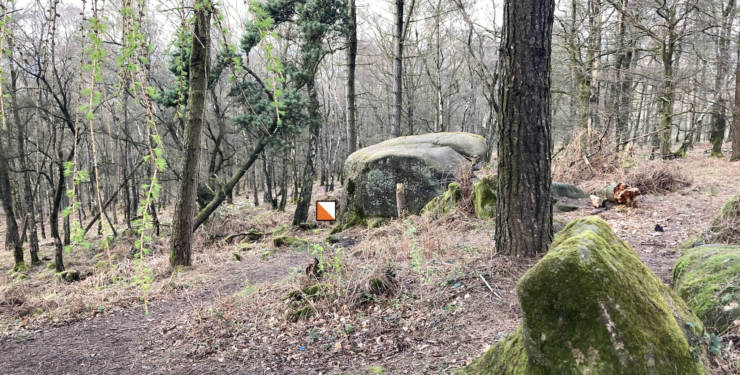
Cromford Moor including Black Rocks and the slope of Cromford Incline offers orienteering that can be physically and mentally challenging! The eastern area consists of steeply contoured beech wood, with boulders proliferating as you move west towards Black Rocks. The inclined plateau east of the trig point has a confusion of knolls.
The event is part of the East Midlands Orienteering League.
Location
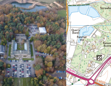
Postcode: DE4 5HS
Grid reference: SK312553
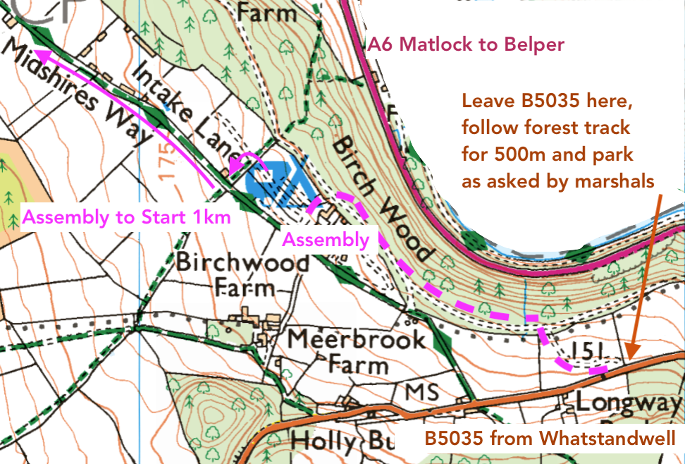
Parking: Parking is at Birchwood Farm Caravan Site. At the A6 junction at the west end of Whatstandwell bridge, take the B5035 (Wirksworth Road) 1 mile, and make a right turn onto narrow woodland track continuing a further mile to the caravan site. Please pay for parking in advance on The Start Kite. The fee is £2 per car. Participants entering on the day are asked to pay this at Registration. This will be located in the Barn, next to the toilet block.
Latest updates about this event
Course lengths as follows:
White 1.1km, 60m, 10 controls
Yellow 1.6km, 80m, 10 controls
Orange 2.2km, 105m, 10 controls
Light Green 2.6km, 140m 13 controls
Very Short Green 2.3km, 115m, 10 controls
Short Green 2.7km, 140m, 12 controls
Green 3.2km, 160m, 17 controls
Blue 3.9km, 205m, 19 controls
Brown 5.2km, 295m, 23 controls, double sided map.
Map scale for all courses 1:7,500, 5m contours. A3 map size.
The Caravan Park shop will open specially for us, selling hot and cold drinks as well as crisps and chocolate – please support them!
Registration and Download will be in the Barn – where there’ll be some table-top map activites and games for young and old (instead of a String Course or Maze at this time of year). The toilets are next to the Barn.
You only need to go to Registration if:
– you wish to enter on the day (and pay on the day for parking, £2 per car)
– you wish to change course (map numbers are tight so this needs to be done at Registration)
– you have hired an SI-card/’dibber’
– you need help
– you or your child has entered White or Yellow, in which case please collect your map at Registration.
If you have entered via the Start Kite and have your own dibber, please go straight to the Start.
Travel
Most people will approach from the A6 Derwent Bridge at Whatstandwell, turning onto the B5035 towards Wirksworth.
If coming from the NORTH, please note the A6 is closed between Matlock and Cromford for tree works.
If coming from the SOUTH, please allow extra time as there are 3-way traffic lights at the junction of the A6 and A610 at Ambergate, with the A6 being closed there between 7pm and 5am.
Assembly to Start: 1km along a track. There is a Clothing Dump at the Start.
Finish to Assembly: 1.2km back along the same track, passing the Clothing Dump.
Planner’s Notes
Cromford Moor is physically tough area with significant climb. I have chosen slightly shorter courses to avoid mindless climb, it is about the journey!
There are significantly more paths on the ground that are un-mapped, please take care when planning your routes. The White and Yellow courses will see ‘smiley’ and ‘sad’ faces to guide them where it is unclear on the ground.
Mapper’s Notes
Maps for all courses are 1:7500, enlarged from 1:10000. A3. Surveyed 2019, using LiDAR data, up-dated 2025 by Richard Parkin. The cairn symbol denotes both the trig point and elsewhere piles of stones.
Punching
The SI controls boxes will be programmed in contactless mode, so that those with SIAC dibbers can ‘waft’. however, please punch at the Start and Finish.
Competitors are required to report to Download once they have started a course, whether or not they have completed the course. Not doing so could result in a needless phone call or search.
Safety
Whistles are compulsory. You may borrow one at the Start if you don’t have one.
In the event of severe weather, waterproof hooded jackets may be compulsory. If this is the case, we will post prominently on the website and have notices in place before you park.
There may be MTBs on the area, move aside if you encounter any.
Cows may be present on the moor, but are secured by fences, again, avoid where necessary.
Please do not climb stone walls, use the gates and marked crossing points.
The bracken has not died off as you would expect for this time of year, remember this when planning.
There are many crags and dangerous rocks, take care around them. All courses have been planned to avoid them.
Due to recent heavy rain, slopes are muddy and slippery. Please take care.
You are responsible for your own safetly, but also, if you see a competitor in distress or injured, please help them, even if it means interrupting your run. There is an emergency number over-printed in magenta on your map. This diverts straight to the Organiser’s mobile.
Please be respectful to other users on the area. It is a popular walking spot.
Clothing and Clothing Dump
Shorts are not allowed in terrain orienteering. There lots of areas of bramble on Cromford Moor, so you’d want full leg-cover anyway. See above about waterproof jackets.
You may leave clothing at a Clothing Dump near to the Start and collect it on your way back from the Finish. Clothing is left at your own risk.
Dogs
Dogs are not allowed on the orienteering courses. Please keeps dogs on leads in Birchwood Farm, and clean up after them.
Current numbers of maps available as of 19/11/2025 at 19:00:
| Course | Entries | Maps |
|---|---|---|
| Brown | 36 | 40 |
| Blue | 71 | 80 |
| Green | 50 | 60 |
| Short Green | 35 | 40 |
| Very Short Green | 7 | 12 |
| Light Green | 14 | 18 |
| Orange | 11 | 16 |
| Yellow | 4 | 12 |
| White | 1 | 8 |
Event details
Courses available : White; Yellow; Orange; Light Green; Very Short Green; Short Green; Green; Blue; Brown;
Start times: 10.30 a.m. - 12.30 p.m.
Registration: 10.00 a.m. - 12.00 noon.
Courses close : 14:30
Toilets : We will be using the caravan site toilets.
Dogs : In car park only
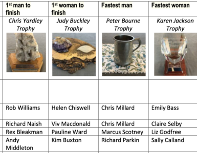
Event officials
Planner: Sally Calland
Controller: John Duckworth
Organiser: Sal Chaffey - Contact: sal.chaffey@gmail.com
Type of event: C (Regional)
Entries and other event details
Fees:
£12 adult, £6 junior. The adult fee is increased to £14 if you are not a current member of British Orienteering. Fee discounts for volunteer helpers. A reduced entry fee of £6 is charged for adults or groups going round together on Orange, Yellow, and White courses. Please email the Organiser if you need the student discount code.
How to enter
Please enter online via the button below.
The closing date for entries is Saturday 22nd November 2025 at 7.00 PM.
Enter NowStart ListYou may however, still enter online subject to map numbers, and entry on the day will be available, again subject to map numbers for different courses when you register. Estimates of map availability for different courses have been added to the Start Kite.