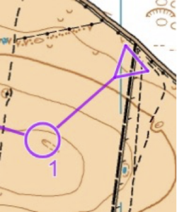
 John Hawkins dips into some Pythagoras Theorem ahead of our event at Longstone Moor!
I was looking at a map of Longstone Moor on Route Gadget (as below) and pondered what would be the best route to control 1. Is it direct – or – should the path be taken for a distance before going out into the terrain and if so where is the ideal point to leave the path.
Of course, we all do the calculation of choosing the route on the day quite quickly taking into account all manner of factors including: the runnability of the path vs the terrain; the visibility; attack points; gradient, how energetic we are feeling etc.
I thought I would simplify the problem, do some maths and see if the results were what I expected.
Here is the simplified problem:
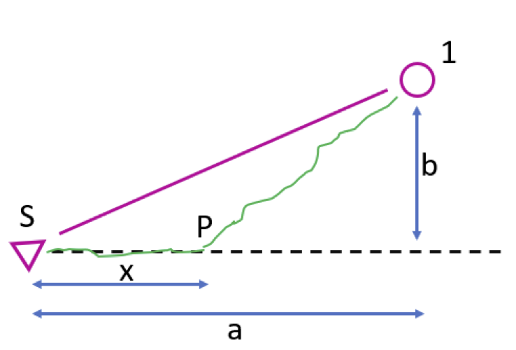
The question then is ‘What is the best distance to run along the path before branching off into the terrain to achieve the quickest time to run to the control?’
The variables I am considering are:
- The perpendicular or shortest distance from the control to the path ‘b’
- The distance from the start along the path to the point that is nearest to the control ‘a’
- The distance to run along the path before branching off into the terrain ‘x’
- The difference in running speed on the path compared to on the terrain
To simplify things further I have looked at three cases as below and make the following assumptions:
- The straight-line distance to the control is 500m
- Running speed along a path is 6 minutes per k
- The area is reasonably flat and consistent
- Attack points are available irrespective of approach angle
Case 1
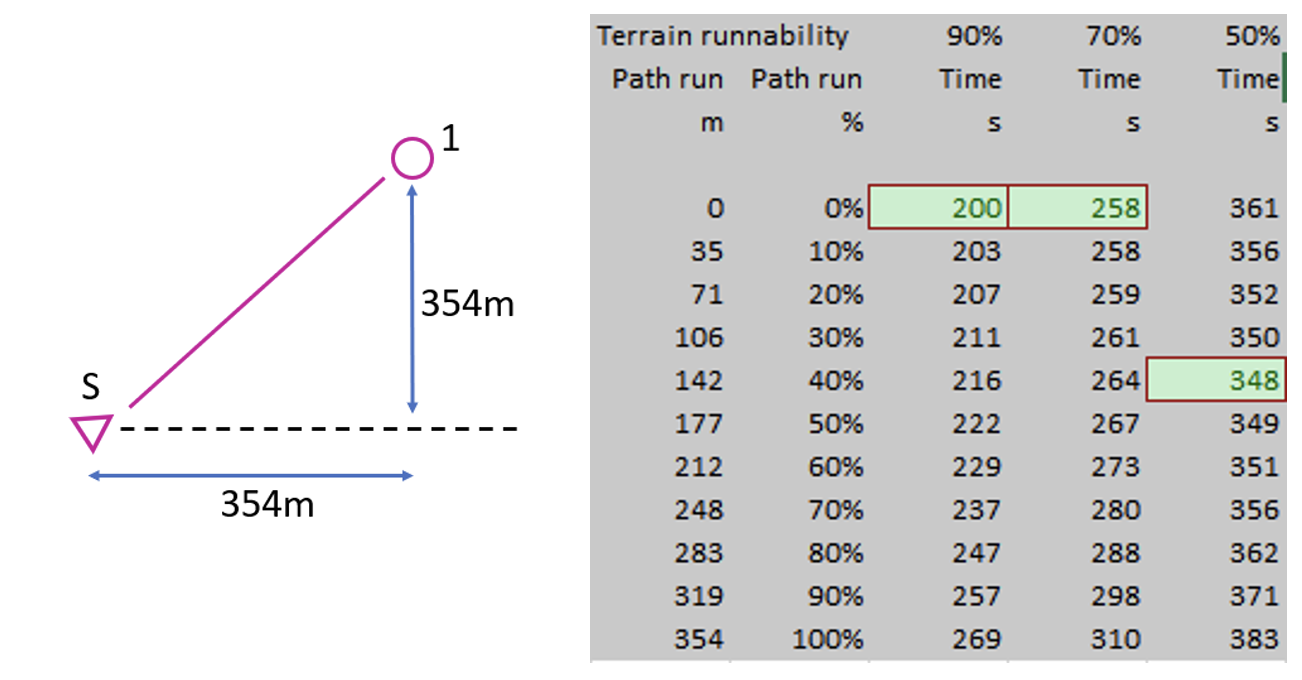
The control is at 45 degrees to the path so distance a = b.
Conclusions:
If terrain runnability vs path runnability is 60% or more then Go Straight
If the terrain runnability is 50% or less then possibly run along the path for about half the side of the triangle and save 13s (3.5%)
Case 2
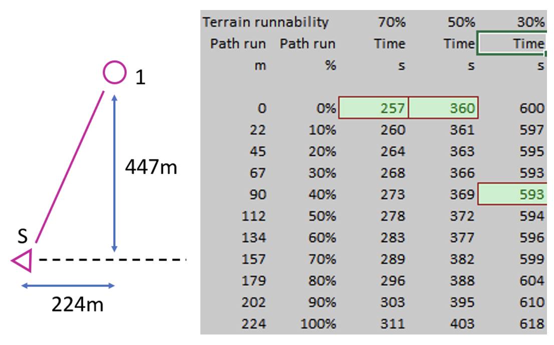
The control is twice as far into the terrain as the route along the path so distance a = b/2
Conclusions:
Terrain runnability down to 40% of path speed shows no benefit in any path running therefore Go Straight
Horrendous terrain runnability of 25% to 30% shows a benefit in running about half the triangle side before heading off into the terrain.
Case 3
The control is half as far into the terrain as the route along the path so distance a = 2b
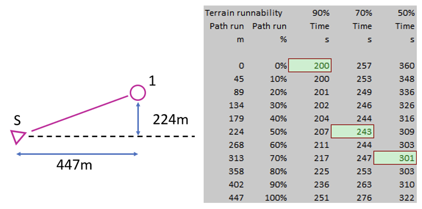
Conclusions:
Now this is a more intersting set of results.
High terrain runnability still suggests Go Straight
70% terrain runnability suggests path runnning for half the triangle side saving 14s (5.5%) over going straight
50% terrain runnability suggests path running for about 70% of the triangle side saving 59s (16.5%) over going straight.
Overall Conclusions
- Where the control is deep into the terrain (Case 2) then there is no real benefit in any path running. Even where terrain running is very slow only a small benefit is theoretically possible.
- Where the control is at about 45 degrees to the path (Case 1) then if the terrain is very slow then it is possible to gain a small advantage by some path running however if terrain running is reasonably navigable then the straight line is the best option.
- Where the control is closer to the path then if the terrain running is medium or slower then there is theoretical advantage to some path running. The advantage is greater the slower the terrain.
- Although this has been calculated on 500m to the control with path running at 6 minutes per k the principles still apply to differing length legs and to different running speeds.
Longstone Moor
Revisiting the Longstone Moor Leg above (212m). Having never run on the area although I have walked there a few years ago. I suggest that the terrain running would be somewhere around 80%. My analysis suggests that taking the straight line would be optimal. Running half the triangle side (85m) on the path would take about 7s (5.5%) longer allowing for a slower speed uphill and of course, in this case, the orienteer also has to decide when to leave the path which is an additional task.
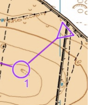
Looking at the routes recorded on Route Gadget for this leg (Blue) – all attempted to go straight. So it appears we all have the skill to find the optimal solution to this problem!